Sunday 30 October 2011

Mississippi River

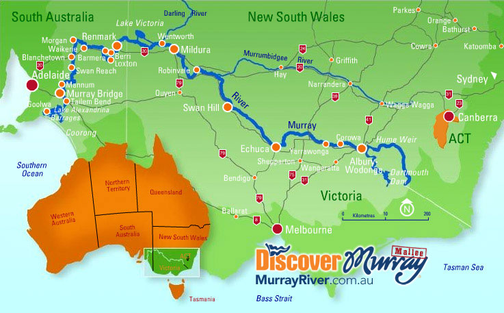
The Mississippi River is the largest river system in North America. It Flows entirely in the United States. This river rises in western Minnesota and meanders slowly southwards for 4,070 km to the Mississippi River Delta at the Gulf of Mexico. The Mississippi ranks fourth longest and tenth largest among the world's rivers.

Images of Mississippi River


Monday 24 October 2011

Pearl Farm Beach

Pearl Farm located in the southern part of the Philippines is the Samal group of Islands, an archipelago consisting of nine islands which stretch out over a land area of 28,000 hectares. Samal is a beautiful, tranquil and exotic island with a coastline adorned with white sand beaches, abundant marine life, rock formations, mangroves, and landscape of coconut palms, flowering plants and fruit bearing trees. The area is blessed with various natural attractions and flourishing flora and fauna.

Photo of Pearl Farm beach Davao
Image of Pearl Farm beach Davao
Beautiful image of Pearl Farm beach Davao
Photo of Pearl Farm beach Davao
Image of Pearl Farm beach Davao

Sunday 16 October 2011

The Baths Beach

The Baths is a beach area on the island of Virgin Gorda among the British Virgin Islands in the Caribbean. "The Baths" are an area of unique geologic formations and one of the BVI's major tourist destinations.

Image of The Baths Beach of Virgin Gorda (BVI).
Image of The Baths Beach of Virgin Gorda (BVI)

Punalu’u Beach (Black Sand Beach)

Punalu’u Beach (also called Black Sand Beach) is a beach between Pāhala and Nāālehu on the Big Island of the U.S. state of Hawaii. The beach has black sand made of basalt and created by lava flowing into the ocean which explodes as it reaches the ocean and cools. This volcanic activity is in the Hawaii Volcanoes National Park. Punaluu is frequented by endangered Hawksbill and Green turtles, which can often be seen basking on the black sand.

Image of a turtle on Punaluu Beach
Image of Black Sand Beach
Top view image of Punaluu Beach
A group of trees on Punaluu Beach
Image of Black Sand Beach

Murray River, Australia

The Murray River is Australia's longest river. At 2,375 kilometers in length, the Murray rises in the Australian Alps, draining the western side of Australia's highest mountains and, for most of its length, meanders across Australia's inland plains, forming the border between New South Wales and Victoria as it flows to the northwest, before turning south for its final 500 kilometers into South Australia, reaching the ocean at Lake Alexandrina. The water of the Murray flows through several lakes that fluctuate in salinity including Lake Alexandrina and The Coorong before emptying through the Murray Mouth into the southeastern portion of the Indian Ocean.

Image of Murray River Australia
Map of Murray River Australia
Image of Murray River Australia

Saturday 15 October 2011

Siachen Glacier

The Siachen Glacier is located in the eastern Karakoram Range in the Himalaya Mountains, just east of the Line of Control between India-Pakistan. It is the longest glacier (70 km long) in the Karakoram and second-longest in the world's non-polar areas. The Siachen Glacier lies immediately south of the great watershed that separates China from the Indian subcontinent in the extensively glaciated portion of the Karakoram. The glacier lies between the Saltoro Ridge immediately to the west and the main Karakoram Range to the east. The Saltoro Ridge originates in the north from the Sia Kangri peak on the China border in the Karakoram Range. Indian army check posts are located on the Siachen glacier. The world's highest battlefield is also located on the glacier at a height of 21,000 feet above the sea level.

Image of Siachen Glacier at moon light
Image of Siachen Glacier at day light
Image of Siachen Glacier

Sunday 9 October 2011

Gobi Desert

The Gobi is a large desert region in Asia. It covers parts of northern and northwestern China, and of southern Mongolia. The Gobi is most notable in history as part of the great Mongol Empire, and as the location of several important cities along the Silk Road. The Gobi measures over 1,610 km from southwest to northeast and 800 km from north to south. The desert is widest in the west, along the line joining the Lake Bosten and the Lop Nor (87°-89° east). It occupies an arc of land 1,295,000 km2 in area as of 2007, making it fifth largest in the world and Asia's largest. Much of the Gobi is not sandy but is covered with bare rock. The Gobi is a cold desert, and it is not uncommon to see frost and occasionally snow on its dunes. The climate of the Gobi is one of great extremes, combined with rapid changes of temperature, not only through the year but even within 24 hours, by as much as 35 °C (95 °F). The Gobi Desert is the source of many important fossil finds,including the first dinosaur eggs.


Image of Gobi Desert

Monday 3 October 2011

Matterhorn Mountain Italy/Switzerland

The Matterhorn is a mountain in the Pennine Alps on the border between Switzerland and Italy. Its summit is 4,478 metres high, making it one of the highest peaks in the Alps. The Theodul Pass, located at the eastern base of the peak, is the lowest passage between its north and south side. Each summer a large number of mountaineers try to climb the Matterhorn via the northeast Hörnli ridge, the most popular route to the summit.

Images of Matterhorn Mountain


Sunday 2 October 2011

Daintree Rainforest

The Daintree Rainforest is a tropical rainforest on the north east coast of Queensland, Australia. At around 1200 square kilometres the Daintree is the largest continuous area of tropical rainforest on the Australian continent. The Daintree Rainforest contains 30% of the frog, reptile and marsupial species in Australia, and 65% of Australia's bat and butterfly species. 18% of bird species in the country can be found in this area. There are also over 12000 species of insects. The rainforest area, named after Richard Daintree, is loosely defined as the area between the Mossman Gorge and the Bloomfield River.

Images of Daintree Rainforest